September has been mild so far, with sunshine dominating the first 16 days and temperatures running about 2° below average. However, a big change arrives midweek. An Air Quality Alert has been issued for Wednesday across much of the state, with ozone levels expected to reach the Unhealthy for Sensitive Groups range. Health officials advise active children, adults, and people with respiratory issues like asthma to limit prolonged outdoor activity.
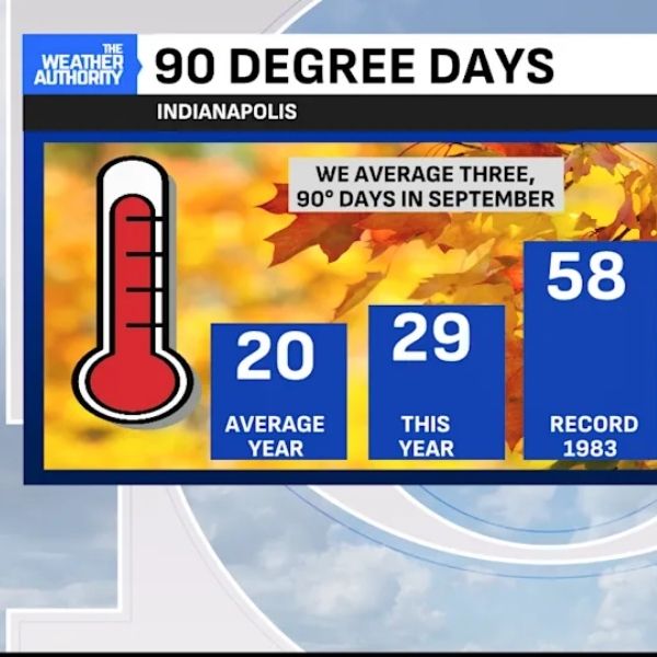
With fall starting in six days, the last week of summer will bring a sharp warm-up. High pressure and an upper-level ridge are keeping Indiana and much of the country quiet, with forecast highs running 10–15° above normal. Central Indiana is likely to hit 90° or higher Wednesday, Thursday, and Friday. Fortunately, dew points will stay in the 50s, meaning it will feel like a dry heat rather than sticky humidity.
Rainfall remains scarce. By mid-September, only 0.73 inches of rain had fallen, nearly an inch below average. Since May 1, the region has been running a 4.5-inch rainfall deficit, and most of central Indiana is now classified as Abnormally Dry or in Moderate Drought. The combination of dry soil and dry air has prompted countywide burn bans, with more counties expected to join.
The forecast calls for dry weather through Friday, with rain chances increasing Saturday as a low-pressure system moves in. This system will bring a daily chance of rain through early next week and drop temperatures back to seasonal levels.
The UV Index peaked in the high range Tuesday, signaling strong sun exposure.
Key takeaways:
-
Air Quality Alert in effect for Wednesday
-
A stretch of 90° days will close out summer
-
Widespread drought and burn bans persist
-
Much-needed rain possible this weekend and early next week
This article has been carefully fact-checked by our editorial team to ensure accuracy and eliminate any misleading information. We are committed to maintaining the highest standards of integrity in our content.


Leave a Reply