With the weekend fast approaching, the severe weather threat for Saturday is starting to come into focus.
A cold front is set to produce widespread rain across Missouri and Illinois on Saturday, potentially producing a few strong to severe thunderstorms.
Severe thunderstorms remain less likely than widespread, beneficial rain. The NOAA Storm Prediction Center issued a Slight Risk (2 out of 5) for much of southern Missouri and the extreme southwest corner of Illinois as the first severe weather threat in months develops on Saturday, Oct. 18. The rest of southern Illinois faces a Marginal Risk (1 out of 5) for severe weather.
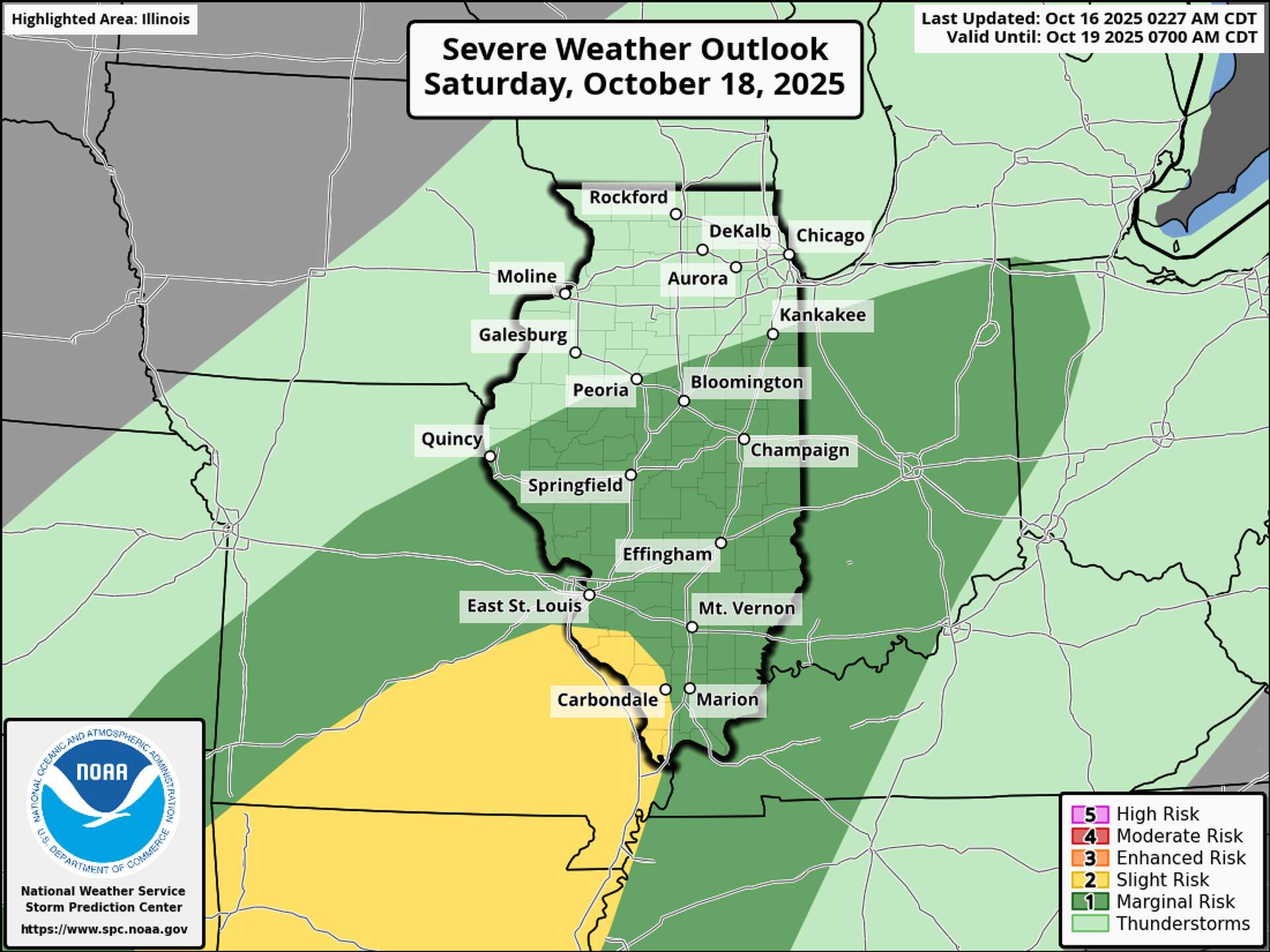
Overall, the primary threat area lies south of St. Louis. The slight risk includes Monroe County and the southern part of St. Clair County, south of the metro region, while the rest of the area remains under a marginal risk.
According to the St. Louis National Weather Service, the chance of severe thunderstorms stays low because of widespread rain and early cloud cover. However, a slower-moving cold front could slightly raise this threat compared to earlier forecasts—particularly if morning rain clears and sunshine develops ahead of the front.
“If instability stays low due to widespread cloud cover and rain, the shear will be too strong to sustain thunderstorms, making strong to severe storms much less likely,” the St. Louis NWS said. “Although the slower front slightly increases the region’s potential for severe weather, widespread rain and a limited severe threat remain the most likely scenario.”
Rainfall would be the most beneficial aspect of this system, as severe to extreme drought conditions now stretch across Illinois, according to the latest U.S. Drought Monitor update. The St. Louis NWS reports that strong moisture return ahead of the system could bring 1.3 to 1.6 inches of rain. Global ensemble models show a 65% chance of at least 0.50 inches of rain across the area and a 20–30% chance of receiving 1.00 inch or more.
“While this won’t be enough to completely relieve the ongoing drought conditions, it will certainly benefit our most drought-impacted areas, including southeast Missouri and southern Illinois,” the St. Louis NWS said in their daily forecast discussion.
Cool, dry air will move into the region after the system passes, ending showers and storms. Sunday’s temperatures will drop nearly 20 degrees from recent days, with highs only in the mid to upper 60s despite mostly clear skies.


Leave a Reply