South Florida is seeing steady rain on Sunday, bringing much-needed moisture to areas like western Miami-Dade and Broward, which are experiencing abnormally dry to moderate drought conditions. While the rain is helpful for soil and vegetation, it could disrupt outdoor plans. The showers are linked to a weak frontal boundary moving north, and occasional sunshine may trigger heavier downpours or even lightning. Strong winds along the Atlantic coast have prompted small craft advisories, and high rip current risks are expected to persist through Monday.
Central Florida & Northern Systems
The frontal boundary will shift northward into Central Florida on Monday, increasing instability. South Florida should see slightly quieter conditions, though coastal showers remain possible. Meanwhile, Florida is sandwiched between two systems this week. A weak frontal boundary will be followed by a cold front accompanied by a low-pressure system pulling moisture from the Gulf.
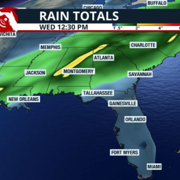
Rain from this next system will begin Monday late afternoon in Pensacola, spreading across the I-10 corridor and the Panhandle overnight into Tuesday. The Panhandle will start drying from west to east Tuesday night, but North and Central Florida will continue to see rain into Wednesday. The heaviest rainfall—up to 3 inches—is expected across the central and western Panhandle, while other areas may see around 1 inch. South Florida is unlikely to receive significant rain, though a slight temperature drop of 1–2°F is possible on Thursday.
Temperature Changes
-
Panhandle: Wednesday morning lows will dip into the low-40s, with highs struggling to reach the mid-60s. Thursday morning will see another cold start in the low-40s.
-
Central Florida: Late-week highs on Thursday and Friday will reach the low-70s, with mornings in the 50s. Winds will shift late in the week, bringing a mild warm-up Friday into the weekend.
-
South Florida: Temperatures remain warmer than average early in the week, with mid-80s expected Tuesday. A slight drop to low-80s occurs Wednesday and Thursday, with evenings in the upper-60s to low-70s. Southerly winds will push highs back to the mid-80s by Friday and Saturday ahead of another system moving through northern Florida next weekend.
Overall, Florida can expect a mix of beneficial rainfall, cooler mornings in the Panhandle and Central regions, and warm, humid conditions returning to South Florida by the weekend.
This article has been carefully fact-checked by our editorial team to ensure accuracy and eliminate any misleading information. We are committed to maintaining the highest standards of integrity in our content.


Leave a Reply