LOS ANGELES – Brace for a windy week, Southern California! The National Weather Service (NWS) warned the region about strong Santa Ana winds and noticeably cooler temperatures that began affecting much of the area Monday. More blustery conditions are expected later in the week.
Weather Alerts Issued
Santa Ana winds moved back into parts of the region Monday as the jet stream continued pushing storms north of Southern California toward the Great Basin.
According to the NWS, today’s Santa Ana event wasn’t strong, but easterly gusts still reached the 40s in mountain areas and the 30s at lower elevations, mainly across Ventura County and the northwestern portion of LA County.
The NWS issued a wind advisory that remained in effect through 3 p.m. for the Western San Gabriel Mountains and the 14 Freeway corridor, where northeast winds of 20 to 30 mph were likely, with gusts reaching up to 50 mph.
A wind advisory was also active until 3 p.m. for the Santa Clarita Valley, the western Santa Monica Mountains Recreational Area, Calabasas, Agoura Hills, and the western San Fernando Valley, where gusts up to 45 mph were possible.
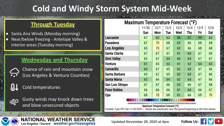
Temperatures along the coast and in the valleys are expected to peak in the mid-60s to low 70s, marking a much cooler event than the Santa Ana that moved through last week.
Winds will taper off in the late afternoon, though some offshore breezes may continue through canyon areas into Tuesday morning.
Areas outside the Santa Ana impacts will stay calm today, with dense fog along the Central Coast and chilly morning lows in sheltered and interior locations.
What they’re saying:
“This is a much cooler event than the Santa Ana last week and temps across (the) coast and valleys should top out in the mid 60s to lower 70s,” according to the NWS. “Winds will diminish in the late afternoon but with some offshore breezes through the canyons into Tuesday morning.”
Looking Ahead
By Tuesday and Wednesday, an offshore flow will weaken and shift onshore, producing a cooling trend near the coast, with little temperature change in the valleys, according to the NWS.
On Thursday, another weak to moderate Santa Ana wind event is expected in the same areas affected on Monday.
From Friday through next weekend, temperatures will warm up as a high-pressure system moves into the eastern Pacific, the NWS said.
La Niña Pattern
The current setup, with Santa Ana winds pushing storms north, reflects a “common La Niña set up.”
La Niña is a climate pattern in the Pacific Ocean defined by cooling surface water in the central and eastern equatorial Pacific, which can strongly influence global weather patterns.
Forecasters expect this pattern to remain in place through at least the first half of December.


Leave a Reply