After nearly a month of unusually warm and dry weather in the Desert Southwest and Southern California, a huge pattern shift is forming, and it is projected to come just in time for the Christmas holiday season. Forecasters are increasingly confident that the continuous ridge that has kept the region dry will weaken and shift east, allowing Pacific storms to move farther south.
A Major Pattern Flip Expected Around Christmas Week
Meteorologists are growing convinced that a deeper West Coast trough will form next week, allowing a series of disturbances to sweep into California. Early forecasts indicate that unsettled weather will arrive around Christmas Day, if not sooner, bringing an end to the extended period of dry warmth.
This is the first significant storm threat in weeks, with repercussions expected across Southern California, Central California, and parts of Arizona and Nevada.
Storms May Tap Into Tropical/Subtropical Pacific Moisture
Forecast information shows that the forthcoming pattern may again connect to warmer tropical or subtropical Pacific moisture plumes, perhaps leading to:
- Higher snow levels initially above 7,000–8,000 feet
- Widespread rainfall statewide
- Potentially heavy precipitation in some regions
However, cooler air behind each system may gradually reduce snow levels, increasing the likelihood of accumulating mountain snowfall later in the trend.
Storm Timing: Still Uncertain but Growing More Likely
Although the first storms are still around ten days away, many agencies—including NOAA and CW3E atmospheric river monitoring—show:
- Increasing probability of moisture plumes hitting California
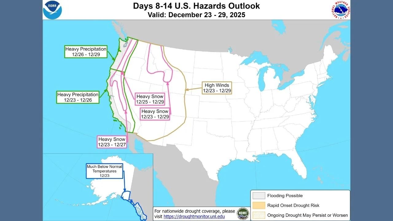
- Elevated risks for heavy precipitation between December 23–29
- Potential for high winds in parts of the West
- Heavy snow possible across mountain ranges, including the Sierra Nevada and Southern California mountains
Confidence grows that this will not be a one-time occurrence but rather a succession of storms continuing through Christmas and possibly beyond.
Model Outlook Highlights
According to NOAA’s 8-14 day forecasts:
- Above-normal precipitation is favored along nearly the entire California coast
- Temperature trends shift cooler as the ridge weakens
- Travel across mountain passes may become increasingly difficult
CW3E atmospheric river probability maps reveal many IVT plumes aimed at California between December 21 and 26, increasing the risk of prolonged wet weather.
Potential Impacts Across the Region
Residents and travelers should plan for:
- Roadway and stream flooding, especially where soils remain dry and hard
- Disrupted holiday travel, particularly through mountain passes
- Heavy mountain snow later in the pattern
- Possible high-elevation chain requirements
Conditions may worsen if numerous storms strike in succession, as current forecasts strongly suggest.


Leave a Reply