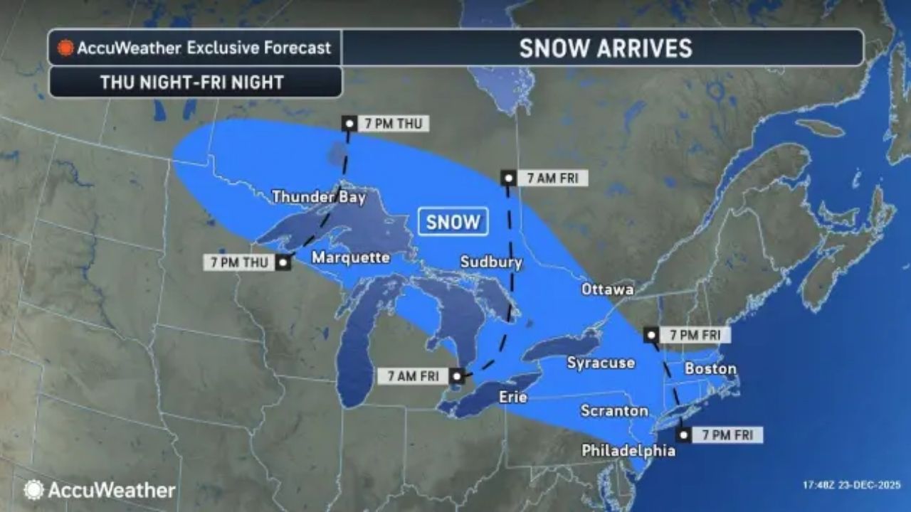
While an upcoming snowfall may be too late for a white Christmas in certain parts of the Northeast, several inches of snow and traffic interruptions are expected from late Thursday night into Friday. Wax the skis.
From Thursday night to Friday, a storm will draw in fresh Arctic air and just enough moisture to produce accumulating snow heavy enough to shovel and plow from central New York to the coasts of New York, New Jersey, and Connecticut.
The fast-moving storm will be a snow lover’s and skier’s dream for the millions of people who have time off during the holidays. However, for those who must travel, this powerful Alberta clipper storm will dump a deep layer of snow on some streets, sidewalks, and highways, the most snow of the season thus far.
AccuWeather meteorologists predict 1-6 inches of snow across the northeastern half of Pennsylvania, northern and central New Jersey, much of New York state, and southern and central New England.
The storm is likely to bring enough snow to shovel and plow in the New York City metro area. Boston will have a second chance to accumulate snow this week.
The Catskill Mountains in southeastern New York and the northeast portion of Pennsylvania are expected to receive 6-12 inches of snow, with an AccuWeather Local StormMax™ of 15 inches.
Kids who receive a sled or saucer for Christmas (or adults who want to break in a snowmobile) will put them to good use in some areas.
Nothing beats real snow for skiing, and the storm should provide enough of it in the Catskills, Berkshires, and Pocono Mountains. When it snows in the major East Coast cities, the ski slopes in the area become extremely crowded, and this time, the Christmas break will assist.
From Thursday night to Friday, the majority of the snow in the central region will fall in Minnesota, Wisconsin, and Michigan’s northern tier.
Icy zone to extend from Minnesota to Delaware
Sleet and freezing rain will fall around the southern border of the accumulating snow.
This icy swath will form over sections of the Dakotas late Thursday and spread to the southwestern half of Pennsylvania, northern Maryland, West Virginia, and northwestern Virginia by Friday afternoon.
The late-week storm is expected to produce a wintry combination of snow and ice in Philadelphia, Baltimore, and Washington, D.C.
Sleet is difficult to move on, but it can provide some traction. However, freezing rain is expected in several locations, making travel conditions considerably worse. Ice accumulation and occasional power outages are expected in southern Michigan, as well as parts of south-central Pennsylvania and the Virginia-West Virginia border.
Fog may form south of the icy zone, where the air is warmer. This could be dense enough to hinder travel in various locations ranging from the Mississippi Valley to the Great Lakes.
Ice for some Christmas Eve and morning
Prior to the late-week snow and ice, a small storm with a light icy mix will move from Michigan late Wednesday and Wednesday evening to parts of Pennsylvania, New York, and New Jersey from Wednesday night to Christmas morning.
This should not be an issue if the surfaces have been treated after previous snow and ice events. However, some untreated surfaces, such as sidewalks, steps, and roadways, may have a thin layer of ice that appears wet. Caution is advised.


Leave a Reply