West Palm Beach, Fla. (WPEC) — A strong cold front is shaping up to be the next major weather change for South Florida, with its arrival expected early next week. While the weekend will stay warm and dry, the front is forecast to bring noticeably cooler and drier conditions by the middle to later part of the week.
Through the weekend, high pressure will remain in control. This large area of sinking air will keep conditions calm and dry, leading to plenty of sunshine, near-zero rain chances, and temperatures running a few degrees above normal.
Afternoon highs today and Sunday will reach the upper 70s to low 80s. Overnight lows will drop into the low to mid 60s along the east coast and into the mid 50s across interior areas.
One concern will be dense morning fog, especially inland. Light winds combined with leftover moisture near the ground could allow fog to become thick at times early Saturday and Sunday mornings, with visibility dropping below a quarter mile in some areas. Drivers should be ready for slower travel during the early morning hours.
Pattern change begins early next week
Early next week, the overall weather pattern across the country will shift as a large trough, a broad dip in the jet stream that promotes cooler weather, moves east from the Rockies. This system will push a strong cold front southward toward Florida.
While some uncertainty remains regarding the exact timing and strength of the front, most forecast models indicate it will move through South Florida around the middle of the week.
Ahead of the front, warm conditions are expected to persist through at least Tuesday, with highs staying in the upper 70s to low 80s.
Cooler air follows the front mid to late week
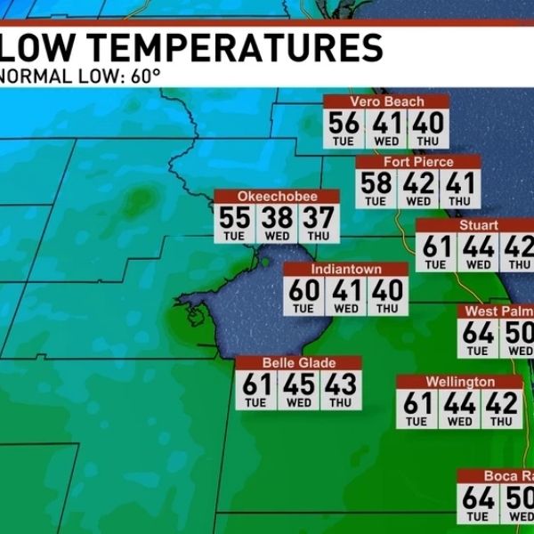
After the front passes, high pressure is forecast to build in behind it, allowing cooler and much drier air to settle across the region. This is when the most noticeable changes are expected.
High temperatures later next week may struggle to climb out of the low 70s, while overnight lows fall into the low 50s along the east coast and into the 40s across interior and Southwest Florida. Some inland locations, including parts of Glades and Hendry counties, could briefly dip below 40 degrees, though confidence in the coldest readings remains moderate.


Leave a Reply