A strong surge of cold air is on the way.
Orlando, Fla. – I truly hope you enjoyed a memorable and joyful Christmas over the past few days. While the weather has been on our side, it’s a great time to keep the celebrations going.
Before diving into the forecast, I genuinely hope the holiday treated you and your loved ones well.
With 2026 just around the corner, many across Central Florida are thinking about goals, resolutions, and fresh starts. At the same time, Mother Nature appears ready to roll out one of her own plans, bringing winter into the region in full force just in time for New Year’s Eve.
High pressure remains positioned near the Gulf Coast, a setup that could lead to foggy conditions Sunday and Monday mornings. This same pattern has kept afternoon temperatures above average and mornings and evenings comfortable. That will change quickly, as Monday night into Tuesday is expected to feel dramatically colder.
A powerful storm system is beginning to develop and will track east across the northern United States. As it does, it will pull cold Canadian air southward, setting the stage for near-freezing and possibly freezing temperatures across parts of Florida.
Sunday and Monday will hold onto the current warm and pleasant conditions a bit longer. High pressure sitting just off the Gulf Coast keeps winds light and moisture trapped near the surface. This combination increases the chance for dense fog during the early morning hours both days.
Computer models indicate a significant amount of moisture compressed within the lowest layer of the atmosphere. With little wind to disperse it, that moisture is likely to show up as surface-level clouds in the form of fog. Anyone heading out early for travel, exercise, or morning plans should be prepared for reduced visibility.
Fog should clear shortly after sunrise, giving way to a mix of sun and clouds. Afternoon highs will again climb into the upper 70s, with a few locations possibly touching 80 degrees across Central Florida. That warmth will be short-lived.
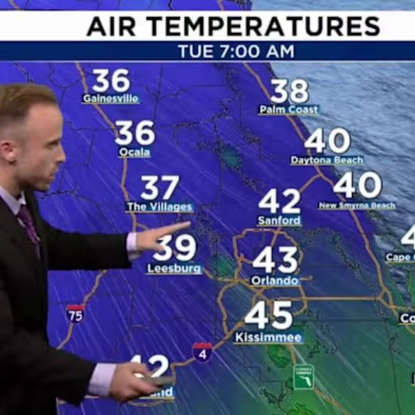
The cold front is expected to arrive late Monday night, with temperatures dropping sharply as Tuesday morning approaches. By then, air temperatures in northern counties could reach or dip to the freezing mark.
The coldest conditions are expected by Wednesday morning. Many locations may see morning lows ranging from the upper 20s to the low or mid 30s, stretching from northern counties into the Orlando metro area.
This dense blast of cold air will also bring stronger winds, both ahead of and behind the front. Those winds will make it feel even colder, pushing wind chill values well into freezing territory.
Tuesday and Wednesday mornings will be especially cold. Residents in northern Central Florida should prepare for extreme wind chill, with feels-like temperatures dropping into the mid 20s across parts of Alachua, Marion, and northern Lake and Sumter counties. Orlando and surrounding areas, including Polk, Osceola, and Brevard counties, could feel like the 30s, particularly Wednesday morning.
These cold temperatures are expected to linger through the New Year. Anyone planning to celebrate outdoors should dress accordingly and consider extra layers. Moving festivities indoors might be a more comfortable option if you want to stay warm while ringing in the New Year.
This article has been carefully fact-checked by our editorial team to ensure accuracy and eliminate any misleading information. We are committed to maintaining the highest standards of integrity in our content.


Leave a Reply