A strong surge of Arctic air is anticipated to rush into Florida early Wednesday morning, causing wind chills in the 20s and low 30s across much of the state. Forecasters predict this could be one of the coldest New Year’s Day wake-ups Florida has seen in recent years.
Wind Chills Will Drop Sharply Across North and Central Florida
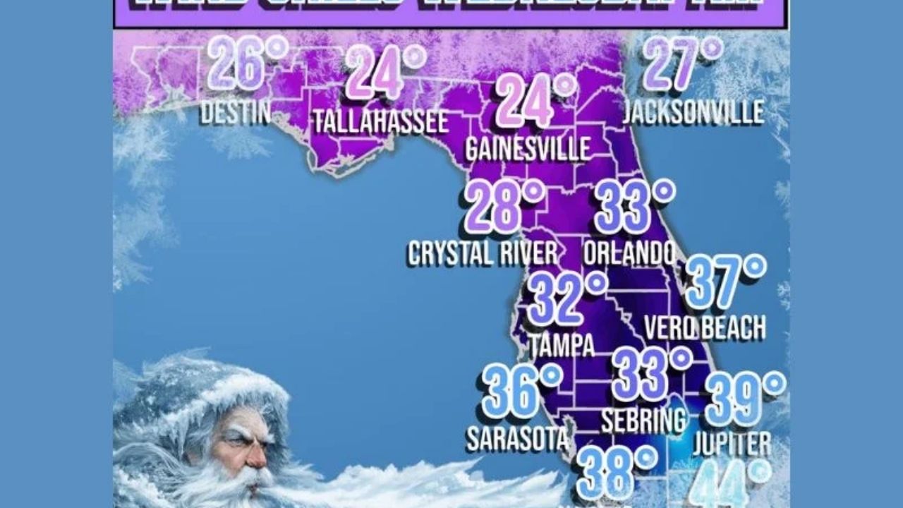
According to the latest forecast models, temperatures will feel far lower than air values, with wind chills ranging from 24 to 33 degrees in major inland towns. The northern portion of the state is predicted to be the heaviest damaged, including:
- Tallahassee: 24° wind chill
- Gainesville: 24° wind chill
- Jacksonville: 27° wind chill
- Crystal River: 28° wind chill
Forecasters remark that winter models frequently warm up as the event approaches, but this time the cold is holding steady, boosting confidence in the upcoming chill.
Central and Southern Florida Will Also Feel the Blast
Areas accustomed to warm winter mornings will not be spared the cold. Wind chills are expected to drop to the lower 30s over Central Florida, including:
- Orlando: 33°
- Tampa: 32°
- Sebring: 33°
Even the southern peninsula is likely to be exceptionally cold.
- Sarasota: 36°
- Naples: 38°
- Miami: 44°
Meteorologists believe this is a classic case of a strong Arctic air mass being forced southward by a vigorous jet stream, resulting in a statewide temperature drop.
Residents Urged to Prepare for a Rare Freeze-Like Morning
While many inland communities will stay above freezing, wind chills in the 20s and low 30s might still cause problems for:
- Sensitive plants
- Outdoor pets
- Early-morning commuters
- Agricultural operations
Cold-weather shelters across numerous counties are bracing for a brief influx as temperatures plummet before morning.


Leave a Reply