Plenty of changes are ahead this week, so enjoy the weekend while it lasts.
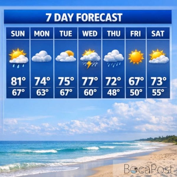
Similar to Saturday, Sunday will feature more clouds than sunshine, but conditions will still be pleasant for spending time outdoors. Winds will be noticeably lighter as a front approaches, and temperatures will run slightly warmer, reaching the low to mid-80s and coming close to record levels, especially in Miami.
There is a chance for showers during the day, mainly across the Florida Keys. After sunset and into the first half of the night, scattered showers are expected across mainland South Florida as the front moves through.
Behind the front, a northeast breeze will develop Monday and Tuesday. Highs will settle into more seasonable levels, while overnight lows remain warmer than normal. Cloud cover will increase at times, bringing occasional passing showers, though long dry stretches are still expected with rain chances around 30%.
By Wednesday, a second front is expected to move in, essentially developing across Florida. This will bring periods of showers and the possibility of isolated thunderstorms.
The rainfall would be welcome, as a moderate drought is currently in place across all of South Florida. At Miami International Airport, one of the region’s primary reporting stations, no measurable rain has been recorded for the past 27 days.
Another front arrives Thursday, bringing morning showers and storms followed by drier, clearing conditions later in the day. This front will introduce the cooler air.
Thursday will remain mild, but Friday will turn noticeably colder, with highs in the 60s and lows near 50 degrees. The chill will be short-lived, with highs returning to the 70s by next weekend, though cool mornings are still expected.








Leave a Reply