ORLANDO, Fla. — A strong cold front is set to sweep across Central Florida on Sunday, bringing the threat of severe storms followed by the coldest temperatures of the season.
Meteorologists warn that thunderstorms could develop between 1 p.m. and 9 p.m., with strong to severe weather possible as the front moves through. Colder air will settle in overnight once the system passes.
Showers and storms are expected to form along the I-4 corridor before shifting east toward the I-95 corridor near Brevard County later in the day. Rain chances range from 30–40%, and a dense fog advisory remains in effect for Polk and Sumter counties until 9 a.m. Sunday, potentially impacting early-morning drivers.
Central Florida sits under a marginal risk for severe weather, meaning isolated strong storms could produce lightning, 40–60 mph wind gusts, small hail, and heavy downpours.
Cold Blast Incoming
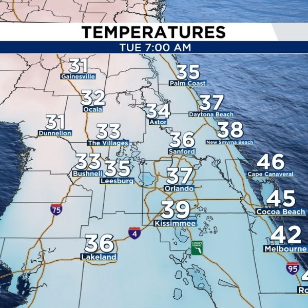
Temperatures will start Monday in the 50s and 60s, but by early Tuesday morning, the region will feel a sharp chill with lows in the 30s and 40s. Brisk winds will make it feel even colder, dropping wind chills into the 20s and 30s in some areas.
Counties north and west of I-4, including Marion and Sumter, face the greatest risk of freezing temperatures and frost. Residents are advised to protect sensitive plants and bring outdoor pets inside before Monday night.
Looking Ahead
After the front passes, sunshine returns for much of the week, with a gradual warm-up into the 70s by Thursday and Friday.
Keep your coats handy, stay tuned to News 6 for updates, and check ClickOrlando.com for the latest Pinpoint Weather alerts.
This article has been carefully fact-checked by our editorial team to ensure accuracy and eliminate any misleading information. We are committed to maintaining the highest standards of integrity in our content.


Leave a Reply