The week began on a gray and soggy note, with clouds and light showers lingering over Philadelphia and parts of South Jersey. Some coastal areas experienced steadier rainfall through the morning.
By this afternoon, skies will begin to clear, allowing sunshine to break through and brighten the day.
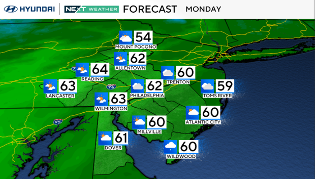
High temperatures will climb into the upper 50s to low 60s. A weak cold front moves through Monday night, making way for sunny skies and light winds on Tuesday, with highs again near 60 degrees.
Midweek Warm-Up Ahead
Wednesday will be the standout day of the week, with high temperatures in the upper 60s—some spots may even come closer to 70. A cold front will move in Wednesday night, possibly triggering an isolated shower north of Philadelphia.
High pressure returns Thursday, keeping the region dry and seasonable with chilly mornings and cool afternoons.
Rain Returns Toward the Weekend
The weather becomes more unsettled by late week. A stronger system is expected to bring widespread rain Friday night into Saturday, with showers lingering into the weekend.
7-Day Forecast
| Day | Forecast | High | Low |
|---|---|---|---|
| Monday | Morning shower | 62 | 46 |
| Tuesday | Sunny | 63 | 47 |
| Wednesday | Sunny and milder | 67 | 42 |
| Thursday | Sunny and cooler | 59 | 49 |
| Friday | Increasing clouds | 65 | 38 |
| Saturday | Few showers | 66 | 55 |
| Sunday | Chance of showers | 64 | 42 |


Leave a Reply