Tuesday Night:
-
Conditions: Increasing cloudiness, fairly mild for mid-October.
-
Showers: Scattered showers developing after midnight.
-
Winds: Northeast 5–10 mph
-
Low: 59°F
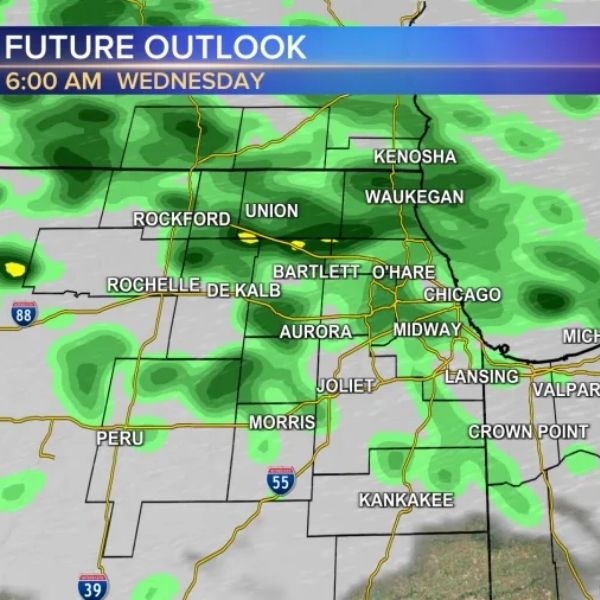
Wednesday:
-
Sky: Predominantly gray autumn skies as a disturbance rides along a frontal boundary across central Illinois, bringing light rain showers in the morning.
-
Sun: Clouds may break late in the day near sunset, allowing a few peeks of sunshine.
-
Highs: Lower 60s across the metro area (no 70s expected).
-
Morning Temps: Mid to upper 50s
-
Winds: East to northeast, influenced by 60-degree lake waters.
Precipitation Outlook:
-
After Wednesday morning showers, the next organized rainfall is expected late Friday night into the weekend.
-
Metro area remains abnormally dry or in moderate drought, so any rainfall will be beneficial.
Temperature Trends:
-
This week: Central U.S. to see above-normal highs later in the week, cooling back closer to normal by Sunday.
-
Oct 14–20: Central U.S. will experience well-above-normal temperatures; western U.S. will see unseasonably cool air.
-
Oct 21–27: Temperature surplus moderates across the Midwest with cooler surges bringing readings closer to normal.
Summary:
Central Illinois residents should expect cooler, mostly gray conditions Wednesday with scattered morning showers, followed by a warmer midweek surge and additional rain chances toward the weekend.
This article has been carefully fact-checked by our editorial team to ensure accuracy and eliminate any misleading information. We are committed to maintaining the highest standards of integrity in our content.


Leave a Reply