A powerful, fast-moving storm is expected to sweep across the East Coast this week, bringing dangerous winds, heavy rain, and sharp temperature drops that could lead to power outages and travel disruptions.
According to the National Weather Service, high pressure will shift offshore on Wednesday, Nov. 5, allowing warm southwest winds to move in before a strong cold front barrels through that night. Gusty winds will linger into Thursday, Nov. 6, as cooler air settles over the region.
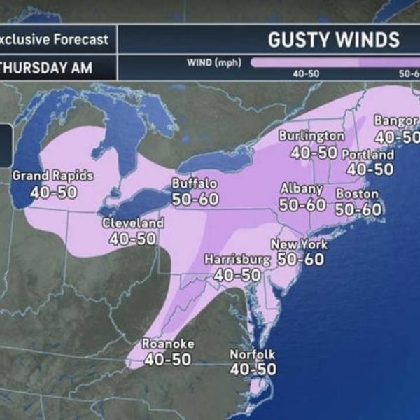
AccuWeather reports that the most intense of several quick-moving storm systems will surge from the Upper Midwest to the Northeast between Wednesday and Thursday, unleashing widespread winds of 40–60 mph and isolated gusts approaching 70 mph.
These strong gusts could topple trees and power lines, cause scattered power outages, and send debris flying, creating hazards for homes and vehicles.
The National Weather Service warns that crosswinds may trigger flight delays at major airports in New York, Boston, and Washington, D.C. Drivers should also expect blustery travel conditions on east–west highways and through wooded areas where downed limbs could block lanes.
The system will bring scattered showers, with a mix of rain and snow possible in higher elevations. Accumulating snow is likely across the Adirondacks, northern New England, and southern Quebec.
Looking ahead to Saturday, Nov. 8, temperatures are forecast to drop sharply, ushering in a December-like chill and even a chance of snow in northern areas and elevated terrain.
“Temperatures will feel more like mid-December or even Christmastime in many places by next week,” said AccuWeather Lead Long-Range Meteorologist Paul Pastelok.
This article has been carefully fact-checked by our editorial team to ensure accuracy and eliminate any misleading information. We are committed to maintaining the highest standards of integrity in our content.


Leave a Reply