Here’s how cold this flash freeze will get
ORLANDO, Fla. – First off, a very happy Thanksgiving to everyone!
Mother Nature is leaning into the holiday spirit, and earlier Thursday many spots saw dense fog along with a quick-moving band of heavy rain and wind sweeping from Marion, Lake, and Sumter counties into Polk and Osceola before fading as dry air pushed in behind it.
That system marked the arrival of a fresh surge of cold, polar air moving down from the north.
By Thursday night, temperatures will once again begin to “fall off a cliff” as many celebrate Thanksgiving and map out their Black Friday shopping plans.
Step outside and you can already feel the shift — the humid subtropical air giving way to a crisp, cooler breeze.
Winds haven’t fully picked up yet. There’s a slight delay behind the fast-moving front, but as high pressure builds southward from the Panhandle and Big Bend into Central Florida, the winds will strengthen.
Closer to midnight Thursday, the leading edge of that cold air will push in more noticeably. As the winds increase, feels-like temperatures will plunge quickly into Friday morning.
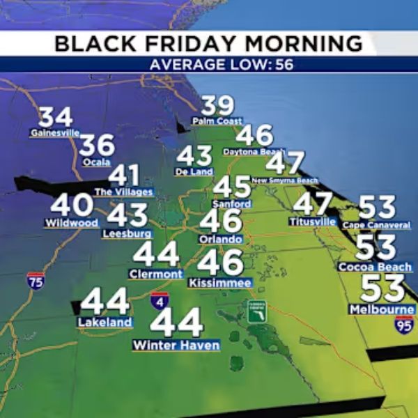
For northern and northwestern areas, temps will feel closest to freezing. Alachua County is under a freeze warning, so those in Gainesville and surrounding areas should prepare for a very chilly start.
Elsewhere, Friday’s sunrise will bring near-freezing conditions, though not quite as intense as the earlier cold snap this month. From Ocala and the Villages eastward to Palm Coast, temperatures will flirt with the 32-degree mark.
Feels-like readings will dip just below or right at freezing, so layer up if you’re heading out early Friday.
Wind chills could fall to around 33–35 degrees, depending on how strong the winds get. Hopefully you haven’t packed away your winter gear from the last temperature drop.
Highs on Friday will struggle to reach the mid to upper 60s, with elevated winds lingering. Layers will be key if you’re out shopping with family or friends.
Expect sunny skies, clear conditions, and crisp, late-fall air sticking around.
Saturday will bring more of the same cold start, but afternoon highs will be a bit warmer than Friday. By Sunday, it will feel as if the cold never happened — a true “flash freeze.”
Saturday’s highs will return to the mid-70s, and by Sunday, the final day of November, temperatures will rebound into the low 80s across much of the region.
Cold-weather fans may wish this polar push would linger, but warmth will return quickly as December approaches.
Early next week, attention shifts to a potential heavy rain event. Forecast models show a surge of moisture and a developing low-pressure system possibly forming near Texas and then tracking east-northeast, increasing rain chances — especially for North Florida.
More details will unfold soon, but first, brace for this short-lived roller coaster of temperatures over the next few days.
This article has been carefully fact-checked by our editorial team to ensure accuracy and eliminate any misleading information. We are committed to maintaining the highest standards of integrity in our content.


Leave a Reply