Timeline of the Cold Snap:
Monday, Dec. 30
-
A strong cold front moves into Central Florida early Monday evening.
-
Temperatures ahead of the front remain above average, with Orlando highs in the upper 70s.
-
Rain chances are minimal, though a brief sprinkle is possible.
-
Coastal areas face dangerous rip currents, and a Small Craft Advisory is in effect Monday night.
Monday Night
-
Much colder air moves in, especially northwest of I-4, where temps could dip into the upper 30s.
-
Inland areas fall to the low-mid 40s, with 50s near the coast.
Tuesday, Dec. 31
-
Breezy and much cooler conditions persist.
-
Highs near 60°F north of I-4, low-mid 60s to the south.
-
Overnight temps drop into the 30s inland, possibly lower 30s in some areas.
Wind Chill Impacts
-
Tuesday morning: wind chills in the 30s across northern/western areas, 40s farther south.
-
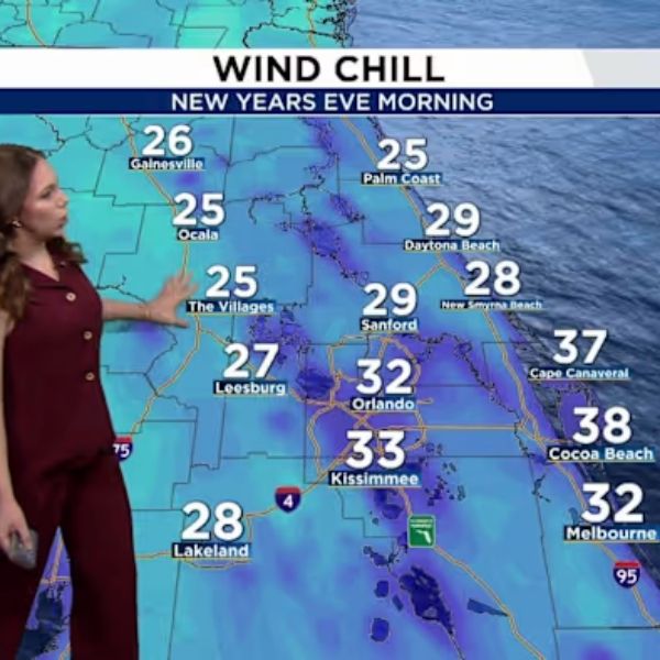
Late Tuesday night into Wednesday morning: wind chills could fall into the upper 20s to low 30s, prompting Cold Weather Advisories or Freeze Watches.
New Year’s Eve (Wednesday, Jan. 1, 2026)
-
Temps dropping quickly as 2026 begins.
-
Inland areas in the upper 30s to 40s, coastal areas slightly warmer.
-
Light breeze will make it feel even colder—jackets and layers recommended for outdoor celebrations.
Rest of the Week
-
Dry, cooler, and drier air remains in place.
-
Highs stay in the 60s through the end of 2025, warming into the low 70s by Friday.
-
A gradual warming trend continues into early next week with milder overnight temperatures and highs returning to the 70s by Saturday and Sunday.
Takeaway:
Central Florida residents should prepare for a sharp drop in temperatures and wind chills below freezing, especially inland, as the week starts. Cold-weather gear is essential for outdoor activities and New Year’s Eve celebrations.


Leave a Reply