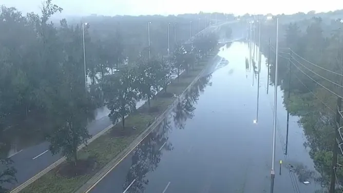
A catastrophic downpour inundated parts of Central Florida late Sunday, with more than 19 inches of rain falling in just a few hours, prompting the National Weather Service (NWS) in Melbourne to issue a rare Flash Flood Emergency for Lake County.
Record Rainfall and Widespread Flooding
Severe thunderstorms swept through the Gulf Coast and Central Florida from Sunday night into Monday morning, submerging cars, closing major roads, and overwhelming drainage systems. The NWS said the event was fueled by the same potent upper-level low-pressure system that caused destructive storms and power outages across Texas over the weekend.
Images from the Florida Department of Transportation showed State Route 46 near Sanford completely underwater as floodwaters lingered into Monday morning. Residents in Eustis, Mount Dora, and Titusville also reported significant street flooding and impassable roads.
Sinkholes and Road Closures
The Lake County Sheriff’s Department confirmed that two sinkholes opened near a roadway in Eustis on Sunday night. Authorities closed several streets in the downtown area as floodwaters continued to rise. Despite the extensive flooding, Lake County schools remained open Monday, with officials confirming that campuses were unaffected.
Ongoing Threat
A Flood Watch remains in effect through 8 p.m. Monday for Orlando and much of east-central Florida, stretching from Daytona Beach to north of Vero Beach, as more rounds of thunderstorms are expected in the afternoon.
As of Monday morning, no injuries had been reported, but emergency officials warned residents to remain alert as residual flooding and additional rainfall could worsen conditions in low-lying areas.
The heaviest rainfall is expected to shift north of Jacksonville by Tuesday, before the cold front responsible for the storms finally moves offshore, bringing much-needed relief to Central Florida.


Leave a Reply