A powerful and fast-moving sequence of Pacific storms is expected to hit the Pacific Northwest from Tuesday to Thursday, bringing severe winds, heavy mountain snow, and additional flooding fears for rivers already swollen by last week’s record rains. Forecast models and National Weather Service advisories indicate that a high-impact setup is building, with several hazards expected from the coast to the Cascades and throughout inland Washington and Oregon.
A Major Windstorm Arrives Tuesday Into Wednesday
On Tuesday, a fast-increasing low-pressure system will strengthen beneath a strong upper-level jet stream, resulting in a severe pressure gradient throughout the region. This arrangement is predicted to produce a widespread windstorm from Tuesday afternoon to early Wednesday.
Forecast maps indicate continuous southerly winds developing first, followed by a sharp shift to westerly winds behind a fast-moving cold front Tuesday night.
- Widespread gusts: 40–55 mph across western Washington and western Oregon
- Stronger wind zones: 60–65 mph possible along the Washington coast, Strait of Juan de Fuca, Port Angeles, Port Townsend, and Whidbey Island
- Eastern Washington: A powerful blast of 50–70 mph wind gusts is possible early Wednesday
- Mountain Passes: Whiteout or blizzard conditions may develop as snow levels crash behind the cold front
During the storm’s peak on Tuesday night, these winds are strong enough to bring down trees, cause power outages, and make travel difficult.
Heavy Mountain Rain, Rapidly Dropping Snow Levels, and Blizzard Risks
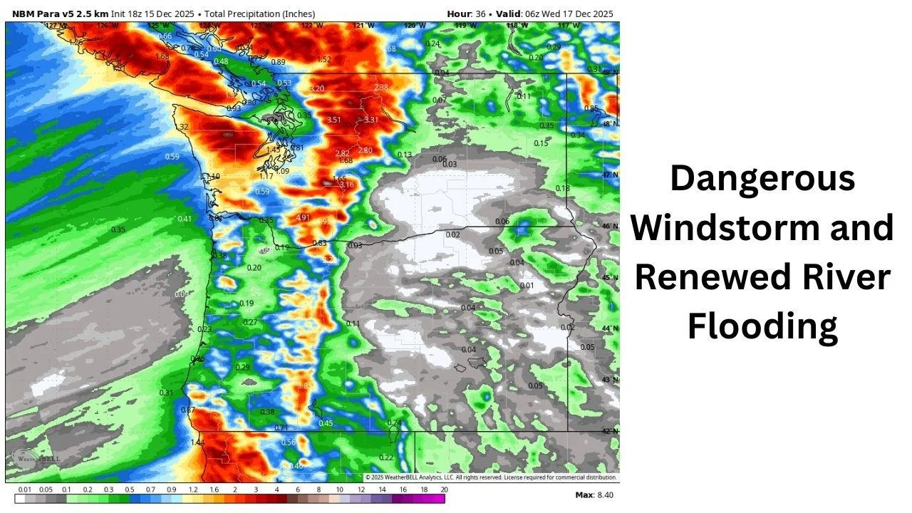
Before cold air arrives, the Cascades and Olympics will receive 3–5 inches of fresh rainfall on already saturated soils, heightening runoff and flooding risks. Lowland accumulations of 0.5-1.5 inches are expected before colder air converts rain to snow in higher elevations.
Behind the front:
- Feet of mountain snow are expected through Wednesday
- Blizzard-like conditions may occur over the passes as winds strengthen and visibility collapses
- Travel could become impossible at times in the Cascades
Meteorologists warn that heavy snow will hinder ongoing flood recovery operations in places that have already suffered infrastructure damage from last week’s storms.
Flooding Expected to Worsen on Multiple Rivers
River gauges remain elevated over much of Washington, and anticipated rainfall is predicted to bring numerous waterways back to or above major flood levels.
Rivers at highest risk include:
- Skagit River
- Snohomish River
- Skykomish River
- Snoqualmie River
- Skokomish River
- Cowlitz River
- Naches River
Significantly lower rainfall levels than normal might cause fast elevations, as soils remain saturated and basins are still recovering from catastrophic flooding. Officials advise residents along these rivers to monitor fresh flood watches and warnings, given the rapid fluctuations in water levels.
Another Storm Arrives Thursday — With a Strong Atmospheric River Aimed at Oregon
The next storm system will arrive on Thursday, bringing with it another plume of Pacific moisture aimed primarily for western Oregon. A weaker low-pressure center going across Washington may still cause gusty winds throughout the region.
Expected impacts include:
- 30–45 mph gusts typical across western WA/OR
- Up to 50–55 mph in wind-prone regions
- Enhanced rainfall across Oregon due to a stronger atmospheric river connection
Forecasters warn that uncertainty remains high, and wind impacts may grow if the low moves further north or deepens more than currently predicted.
Looking Ahead: Cooler Weekend, Possible Lowland Snow, and Continued Active Pattern
By the weekend, cooler air will have settled in, potentially dropping snow levels enough to produce lowland flakes in sections of the region. More storms appear to be forming in the Pacific, ensuring that the active trend continues until next week.
The following conditions should prepare residents of Washington and Oregon:
- Additional rounds of rain
- Strong winds
- Ongoing river flooding
- Difficult mountain travel


Leave a Reply