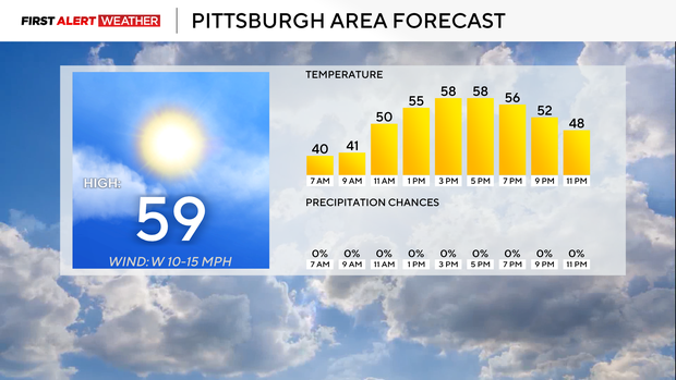
The Pittsburgh area is in for a pleasant day today before rain chances return tomorrow.
High temperatures will hover near 60 degrees, accompanied by breezy west winds that could produce gusts up to 30 mph. While sunshine will dominate most of the day, a few cloudy hours are expected early this morning. By noon, temperatures should be in the low 50s.
Looking Ahead to Midweek
Temperatures will warm into the mid-60s on Wednesday ahead of light rain. Only about 0.01 to 0.02 inches of rainfall is expected. Rain chances increase again on Friday, with additional showers possible from Sunday into Monday morning.
Big Temperature Drop Next Week
One of the most notable changes comes early next week when temperatures take a sharp dive. Next Monday’s high is forecast to reach only 39 degrees. Highs will stay in the 40s on Tuesday and Wednesday.
Despite the cold start, temperatures are expected to rebound by next weekend, soaring well above average. The middle of the month through Thanksgiving is looking unseasonably warm for this time of year.
Rain and Possible Snow Early Next Week
There is also a chance for rain and snow from Sunday afternoon into Monday morning. If you’re south of I-80, any snow accumulation will likely be nothing more than a light dusting. However, with temperatures dropping quickly to near 30 degrees, slick spots could develop on the roads.
Salt trucks are expected to be out Sunday evening and Monday morning to prevent icy conditions. Aside from a few potentially hazardous slick spots, impacts from this winter weather system should be minimal.


Leave a Reply