A major winter storm is forecast to impact the Northeast with heavy snow, sleet, and ice, creating hazardous travel conditions for the post-Christmas period.
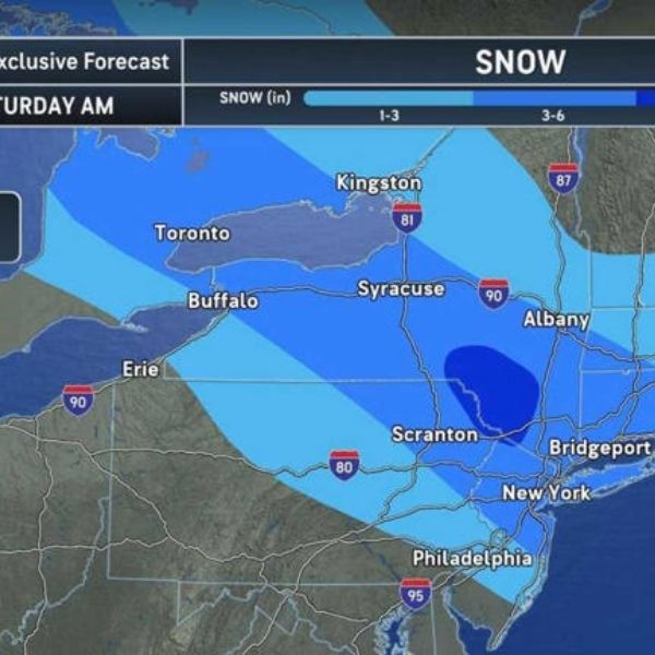
The National Weather Service Weather Prediction Center says the storm will move in late Friday afternoon, Dec. 26, and continue through early Saturday afternoon, Dec. 27. Snowfall totals of 3–6 inches are expected across central and southeast New York, northern New Jersey, Connecticut, and southwest Massachusetts, with some areas seeing up to 6 inches. Higher elevations could see 6–12 inches. Northeast Pennsylvania, northern New Jersey, and the New York City metro region face a 50–70% chance of more than 6 inches.
“Icy wintry mix of freezing rain and sleet will cause hazardous travel from Michigan eastward across much of Pennsylvania and into the Mid-Atlantic,” NOAA forecasters warned. Ice accumulations of over one-quarter inch are expected from northwest Pennsylvania to western Maryland, with potential tree damage and power outages. Hazardous ice is also likely for the DC, Baltimore, and Philadelphia metro areas.
Snow will begin in the interior Northeast Friday morning, reaching major cities including New York City, Long Island, Philadelphia, and Boston around 7 p.m. Friday, continuing overnight with slick roads and possible power outages.
AccuWeather Senior Meteorologist Tyler Roys cautioned that travel could be delayed or disrupted for millions returning home after Christmas. The southern edge of the storm will see a wintry mix of freezing rain and sleet, creating icy conditions, including on ski slopes in the Appalachians.
This article has been carefully fact-checked by our editorial team to ensure accuracy and eliminate any misleading information. We are committed to maintaining the highest standards of integrity in our content.


Leave a Reply