With the main storm track expected to stay well north of the Sunshine State over the next week, warmer and drier conditions will continue to dominate Florida’s forecast.
A broad ridge of high pressure is projected to remain in control through most of the pre-Thanksgiving period, keeping temperatures above seasonal norms and limiting opportunities for meaningful rainfall.
Typically, afternoon highs in mid-November range from about 70 degrees across the Panhandle to the 80s in South Florida.
During the upcoming week, temperature anomalies will be most noticeable along the Interstate 10 corridor, where a late-fall heat wave will create mild overnight lows and daytime highs running 5 to 10 degrees above average.
Wednesday appears to be the warmest day of the stretch, with most communities expected to reach at least the lower 80s statewide.
A few weak frontal boundaries are forecast to approach the region during the week, but none are expected to be strong enough to bring widespread rain chances or noticeably cooler air.
Some weather hazards will still develop despite the calm pattern.
Light winds and humid mornings will support fog formation around daybreak. Visibilities may drop quickly for morning commuters in areas with denser fog.
The ongoing lack of rain will also continue to expand drought conditions.
Nearly half the state is now officially classified in some stage of drought, and the threat of wildfires is expected to rise.
Overall, the setup reflects a classic La Niña pattern, which often leaves Florida warmer and drier than average while the main storm energy passes to the north.
Look ahead to Thanksgiving Day week
Early indications suggest the week of Nov. 24 will start much like the previous one ended — warm, quiet, and with minimal chances for precipitation across Florida.
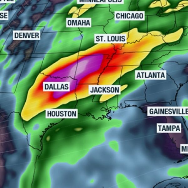
While other parts of the country may deal with turbulent weather, including severe thunderstorms and pockets of ice and snow, the Sunshine State appears likely to avoid any widespread impacts as Thanksgiving approaches.
Forecast models show the potential for a pattern shift just after the holiday, but for now, if your travel plans keep you in Florida, no major impacts appear likely.
Temperatures through most of the week are expected to stay well above late-November averages, with some locations, especially along the I-10 corridor, approaching record highs.
The forecast will continue to be refined as we get closer to Nov. 27, especially with several storm systems moving across the central and eastern U.S.


Leave a Reply