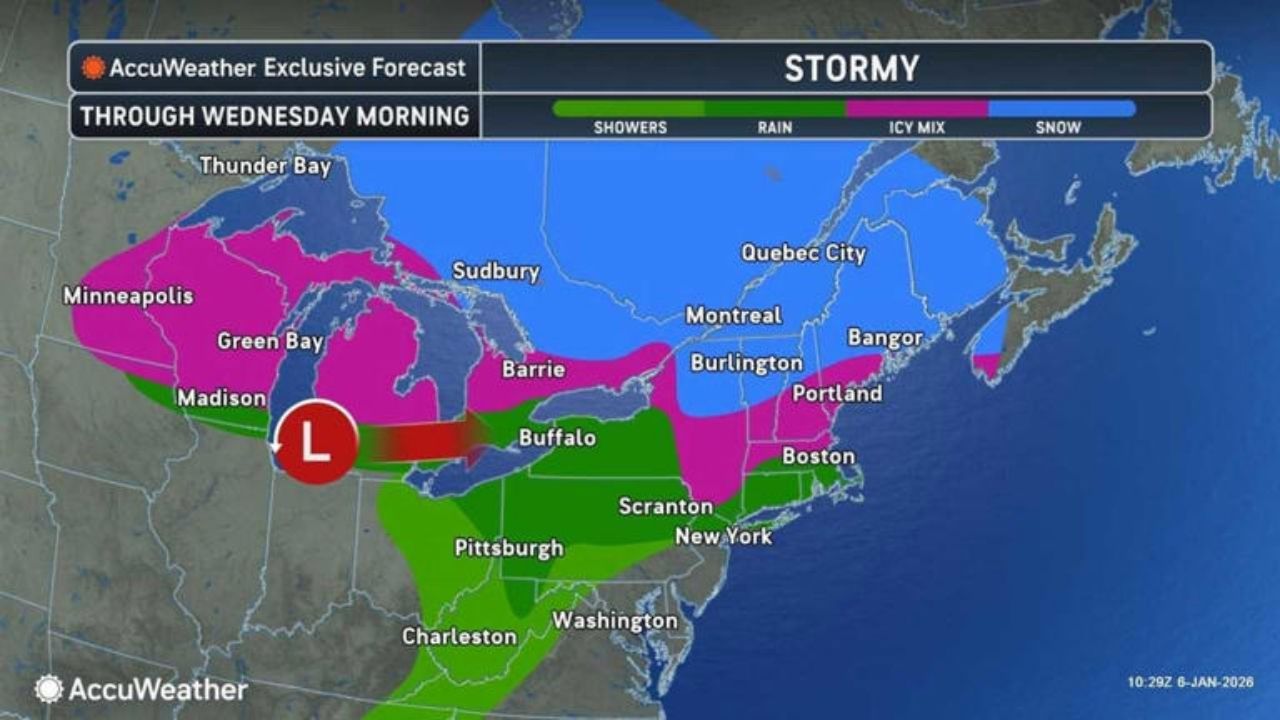
A storm system is now approaching the Northeast overnight Tuesday, Jan. 6, into Wednesday, Jan. 7, bringing a sloppy mix of snow, sleet, and freezing rain that could make for a treacherous morning commute.
According to the National Weather Service, freezing rain arrived in interior regions of most of the Northeast on Tuesday and early Wednesday, with some small ice accumulations expected. This increases the likelihood of slippery conditions, thus motorists should exercise caution when traveling in these locations.
Tuesday night’s light snow will be mixed with freezing rain or drizzle, particularly in inland New York, northern Pennsylvania, and southeast Connecticut. Tuesday’s highs will be in the upper 30s to lower 40s, with mostly dry conditions during the day and precipitation later in the night.
From Tuesday, January 6, to Wednesday morning, January 7, a system will bring a mix of rain and sleet farther inland.
AccuWeather predicts that this initial phase will bring snow, sleet, and freezing rain to the Northeast and New England through midweek, with 1 to 6 inches of snow possible in many regions and up to 1 foot in higher elevations of the Green and White Mountains, as well as parts of Canada.
Even a small layer of ice can make untreated roads and bridges treacherous in the evenings and nights.AccuWeather Senior Meteorologist Tyler Roys advised travelers on the storm’s northern edge to expect slippery and hazardous road conditions, as well as potential travel delays.
Accumulations of 1-6 inches are expected, with areas of Canada and the Green and White Mountains receiving up to a foot of snow. Even minor icing can create hazardous circumstances on unprotected roads and elevated surfaces.
Following this wintry round, a more significant storm is expected later this week. According to AccuWeather, a second system will travel from Texas to the Great Lakes on Thursday, January 8, and Friday, January 9, before arriving in the Northeast during the weekend.
This storm will bring heavy rain near the coast, snow inland, and potentially thunderstorms, creating significant travel delays from Friday to Saturday, January 10.
Coastal routes from Washington to Boston are more likely to get chilly, soaking rain from the late-week system, although locations north and west are more likely to accumulate snow or a wintry mix as colder air bleeds back in.
The exact time and type of precipitation will be determined by the storm’s route and the amount of cold air remaining in central New York and New England.
Coastal locations from Washington to Boston are forecast to have cool, soaking rain for a while, while areas further north and west are more likely to get snow or a wintry mix as colder air returns.
Prepare for changing conditions, allow additional time for commutes, and keep an eye out for revised forecasts and advisories as the late-week storm approaches.


Leave a Reply