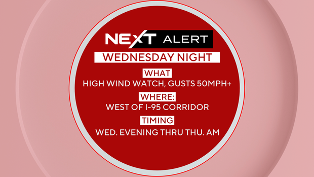
A wind advisory is in effect for the Philadelphia area Wednesday evening as powerful gusts are expected to reach up to 50 mph in and around the city and as high as 55 mph along the Jersey Shore.
A cold front will move through Wednesday night, bringing a few showers, mainly north of Philadelphia. With high winds expected, a NEXT Weather Alert is in place from Wednesday night through Thursday morning due to the risk of tree damage and power outages. The strongest winds are expected between 11 p.m. and 2 a.m.
Cooling Down Before a Brief Warm-Up
Temperatures will drop into the 40s and 50s by Thursday before rebounding to the 60s on Friday.
A stronger weather system is set to arrive Friday night, bringing rain and gusty winds. This will kick off a more unsettled weather pattern for the weekend, with the highest chance of rain coming on Sunday.
Turning Much Colder Next Week
Cold air arrives early next week. High temperatures on Monday and Tuesday will stay in the mid to upper 40s, with widespread freezing temperatures likely by Tuesday morning.
7-Day Forecast
| Day | Forecast | High | Low |
|---|---|---|---|
| Wednesday | Windy, a few p.m. showers | 68 | 40 |
| Thursday | Cooler | 58 | 48 |
| Friday | A late shower | 62 | 39 |
| Saturday | Mixed skies | 68 | 56 |
| Sunday | Afternoon/evening showers | 63 | 49 |
| Monday | The big chill | 48 | 40 |
| Tuesday | Sunny and frosty | 47 | 33 |


Leave a Reply