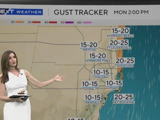
South Florida started Monday with mild temperatures in the low 70s. Highs are expected to reach the mid-80s under mostly sunny skies. Winds from the northeast will strengthen throughout the day, with gusts up to 20 mph. While a few showers are possible, rain chances remain low.
The increasing winds are creating dangerous marine and beach conditions. A Small Craft Advisory is in effect for Atlantic waters from Monday at 1 p.m. through Tuesday evening due to seas of 5–8 feet and winds of 20–25 knots. For the Florida Keys waters, a Small Craft Caution has been issued, and an advisory may be required tonight. Strong rip currents and elevated waves will make swimming and surfing hazardous. A high risk of rip currents is in place along Atlantic beaches through 7 p.m. Wednesday.
A cold front moving through Monday will bring slightly cooler temperatures by Tuesday morning. Lows will dip to the upper 60s and low 70s. Highs will stay near 80 degrees with mostly dry conditions.
Starting Tuesday morning, a coastal flood statement goes into effect. The combination of king tides and persistent onshore winds could cause minor coastal flooding along South Florida’s east coast from Wednesday through Friday.
By Wednesday, highs will return to the low 80s, with continued gusty winds and low rain chances. Moisture increases late in the week, raising the potential for showers. Spotty showers are possible Thursday and Friday, with scattered showers expected over the weekend.
This weekend, temperatures will climb into the upper 80s, with warmer and more humid conditions returning.


Leave a Reply